PICK UP
ongoing project web
拠点形成事業
|
科研費 基盤研究(S)
|
PAWCs
|
推進費SII-8
|
Our group is looking for new members who would like to do research in our laboratory (graduate students, research students, etc.) or support research such as data analysis (undergraduate to graduate students). We are also happy to accept JSPS PostDoc researchers. If you are interested, please contact us by e-mail.
我々のグループでは、本研究室で研究をしてみたい(大学院生、研究生など)、データ解析など研究のお手伝いをしてみたい(学部生~大学院生他)などの方々を広く募集しています。学振PDなどの受入も大歓迎です。興味があれば、連絡(メール)下さい。
大学院(修士・博士)への入学希望(2025年4月入学or 2024年10月入学)の方々の説明・面談も随時行っております。大学からの入試情報はコチラ。説明会(5月25日)の情報はコチラ。
我々のグループでは、本研究室で研究をしてみたい(大学院生、研究生など)、データ解析など研究のお手伝いをしてみたい(学部生~大学院生他)などの方々を広く募集しています。学振PDなどの受入も大歓迎です。興味があれば、連絡(メール)下さい。
大学院(修士・博士)への入学希望(2025年4月入学or 2024年10月入学)の方々の説明・面談も随時行っております。大学からの入試情報はコチラ。説明会(5月25日)の情報はコチラ。
NEWS (see all)
2024/05/12: Available datasets from lab (see DATASET) is updated. Himawari-8 surface reflectance and land surface temperature are added.
2024/05/06: A new paper first authored by a PhD student, Liu Zhiyan, about Land Surface Temperature estimation at dawn/dusk using MERSI-LL FY-3E has publised in IEEE JSTARS. Congratulations, Zhiyan !
2023/12/27: We had "end of the year party" (忘年会).
2023/12/17: We visited NASA Ames Research Center and joined AGU 2023 Fall Meeting.
2023/12/03: 自然エネルギーフォーラム2023で講演しました
2023/12/02: We (12 members!) joined AsiaFlux 2023 Conference, Jeju, Korea.
2023/11/24: Mr. Riku Kawase (Almini of Ichii lab) visited us.
2023/11/21: We had three presentations in iLEAPS-Japan Conference, Sapporo.
2023/11/10: K. Ichii joined AOMSUC-13, Busan, Korea.
2023/11/07: 千葉大学学長主催講演会シリーズ第4回での講演をしました
2023/11/01: Ms. Mari Suzuki joined as a technical assistant. Welcome!
2023/10/29: 地理情報システム学会の企画セッションでコメンテータを務めました
2023/10/26: K. Ichii and Y. Yamamoto joined Meteorological Society of Japan 2023 Fall Meeting.
2023/10/17: K. Ichii joined Global-ERCaN Conference, Chinese Academy of Science as an invited speaker.
2023/10/06: Eight members joinded Inter-lab Study Meeting in Shinshu University.
2023/10/01: Dr. Shuai Shao joined as a researcher. Welcome !
2023/09/28: Ms. Yueru WEN finished her master in Chiba University. She will continuously work here as technical supporting staff from October.
2023/09/24: 8月に開催した東京都科学イベントの発表会が東京にて開催されました。当研究室で研究活動をした5名の高校生の皆さん、非常によい発表ができたと思っております!おつかれさまでした&これから「リモセン」「地球環境」に興味を持つきっかけになれば幸いです。
2023/09/22: Kazuhito Ichii and Yuhei Yamamoto joined A3 Forsight Program Meeting in Beijing, China. We enjoyed the workshop, field excursion, and great Chinese foods. Great meeting of China-Korea-Japan international collaboration.
2023/09/19: 大学院入試、インターンシップお疲れさま会をおこないました
2023/08/24: 東京都得意な才能を伸ばす教室に参加の5名の高校生の方々が当研究室で研究体験を行いました。Google Earth Engineを用いた地球環境データ(リモセンデータ)の解析を行い、プログラミングなども行いました。2日間お疲れさまでした!
2023/08/22: Prof Tsolmon Renchin, National University of Mongolia, visited us to discuss collaborative project.
2023/08/21: 本日より2週間の予定で、木更津高等専門学校の学生2名がインターンシップとして、本研究室に滞在します。ひまわり8号の幾何補正の精度についていろいろと調べてもらう予定です。頑張りましょう!
2023/08/07-09: We had the First Expert Workshop on Geostationary Satellite in University of Hawaii, Manoa. K. Ichii is one of the main organizers, and seven lab members join the workshop.
2023/07/07: CHIBADAI NEXT English version. "Predicting Future CO2 Absorption and Emissions in Terrestrial Ecosystems: International Geostationary Meteorological Satellite Network for Accurate Estimation"- the whole article
2023/05/23: Chieko Fujita joined us as a technical assistant. Welcome !
2023/05/16: 山本特任助教の論文成果のプレス記事を千葉大学より出しました。気象衛星ひまわりを用いた植生モニタリングに関する成果です。気象衛星で植物の熱中症を診断~温度日変化の波形が水分不足のサインを捉える~。
2023/05/08: 市井がCHIBADAI NEXT にて紹介されました。「カーボンニュートラル実現のために大学ができること #5 陸域生態系のCO2吸収・排出量の将来を予測する〜国際静止気象衛星ネットワークを活用して正確な測定に挑戦」→記事はこちら
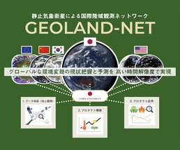
2023/04/30: 市井が研究代表者を務めるJSPS研究拠点形成事業(静止衛星・陸面ネットワークー"GEOLAND-NET")につきまして、プロジェクトページをいろいろとアップしました。是非ご覧ください!
2023/04/30: 遅ればせながら、昨年度の卒論・修論のタイトル・名前をアップしました。
2023/04/26: 本年度は2名がJSPS Research Fellow (DC1, 2)に採用されました。おめでとうございます!
2023/04/20: 大学院の入試説明会・コース説明会を5月13日(土)に開催します。参加希望される方は、CEReSのWebサイトの該当ページより、申込をお願いします。質問などあれば問い合わせも歓迎いたします。
2023/04/10: A new paper on application of Himawari-8 based diurnal variation in LST for monitoring vegetation heat/drought stress has just accepted and released by Remote Sensing of Environment.
2023/04/05: Two members joined us. Welcome, Moena Fukatsu and Riku Fukuta !
2023/04/01: Reina Watanabe joined us as a technical assistant. Welcome !
2024/05/06: A new paper first authored by a PhD student, Liu Zhiyan, about Land Surface Temperature estimation at dawn/dusk using MERSI-LL FY-3E has publised in IEEE JSTARS. Congratulations, Zhiyan !
2023/12/27: We had "end of the year party" (忘年会).
2023/12/17: We visited NASA Ames Research Center and joined AGU 2023 Fall Meeting.
2023/12/03: 自然エネルギーフォーラム2023で講演しました
2023/12/02: We (12 members!) joined AsiaFlux 2023 Conference, Jeju, Korea.
2023/11/24: Mr. Riku Kawase (Almini of Ichii lab) visited us.
2023/11/21: We had three presentations in iLEAPS-Japan Conference, Sapporo.
2023/11/10: K. Ichii joined AOMSUC-13, Busan, Korea.
2023/11/07: 千葉大学学長主催講演会シリーズ第4回での講演をしました
2023/11/01: Ms. Mari Suzuki joined as a technical assistant. Welcome!
2023/10/29: 地理情報システム学会の企画セッションでコメンテータを務めました
2023/10/26: K. Ichii and Y. Yamamoto joined Meteorological Society of Japan 2023 Fall Meeting.
2023/10/17: K. Ichii joined Global-ERCaN Conference, Chinese Academy of Science as an invited speaker.
2023/10/06: Eight members joinded Inter-lab Study Meeting in Shinshu University.
2023/10/01: Dr. Shuai Shao joined as a researcher. Welcome !
2023/09/28: Ms. Yueru WEN finished her master in Chiba University. She will continuously work here as technical supporting staff from October.
2023/09/24: 8月に開催した東京都科学イベントの発表会が東京にて開催されました。当研究室で研究活動をした5名の高校生の皆さん、非常によい発表ができたと思っております!おつかれさまでした&これから「リモセン」「地球環境」に興味を持つきっかけになれば幸いです。
2023/09/22: Kazuhito Ichii and Yuhei Yamamoto joined A3 Forsight Program Meeting in Beijing, China. We enjoyed the workshop, field excursion, and great Chinese foods. Great meeting of China-Korea-Japan international collaboration.
2023/09/19: 大学院入試、インターンシップお疲れさま会をおこないました
2023/08/24: 東京都得意な才能を伸ばす教室に参加の5名の高校生の方々が当研究室で研究体験を行いました。Google Earth Engineを用いた地球環境データ(リモセンデータ)の解析を行い、プログラミングなども行いました。2日間お疲れさまでした!
2023/08/22: Prof Tsolmon Renchin, National University of Mongolia, visited us to discuss collaborative project.
2023/08/21: 本日より2週間の予定で、木更津高等専門学校の学生2名がインターンシップとして、本研究室に滞在します。ひまわり8号の幾何補正の精度についていろいろと調べてもらう予定です。頑張りましょう!
2023/08/07-09: We had the First Expert Workshop on Geostationary Satellite in University of Hawaii, Manoa. K. Ichii is one of the main organizers, and seven lab members join the workshop.
2023/07/07: CHIBADAI NEXT English version. "Predicting Future CO2 Absorption and Emissions in Terrestrial Ecosystems: International Geostationary Meteorological Satellite Network for Accurate Estimation"- the whole article
2023/05/23: Chieko Fujita joined us as a technical assistant. Welcome !
2023/05/16: 山本特任助教の論文成果のプレス記事を千葉大学より出しました。気象衛星ひまわりを用いた植生モニタリングに関する成果です。気象衛星で植物の熱中症を診断~温度日変化の波形が水分不足のサインを捉える~。
2023/05/08: 市井がCHIBADAI NEXT にて紹介されました。「カーボンニュートラル実現のために大学ができること #5 陸域生態系のCO2吸収・排出量の将来を予測する〜国際静止気象衛星ネットワークを活用して正確な測定に挑戦」→記事はこちら
2023/04/30: 市井が研究代表者を務めるJSPS研究拠点形成事業(静止衛星・陸面ネットワークー"GEOLAND-NET")につきまして、プロジェクトページをいろいろとアップしました。是非ご覧ください!
2023/04/30: 遅ればせながら、昨年度の卒論・修論のタイトル・名前をアップしました。
2023/04/26: 本年度は2名がJSPS Research Fellow (DC1, 2)に採用されました。おめでとうございます!
2023/04/20: 大学院の入試説明会・コース説明会を5月13日(土)に開催します。参加希望される方は、CEReSのWebサイトの該当ページより、申込をお願いします。質問などあれば問い合わせも歓迎いたします。
2023/04/10: A new paper on application of Himawari-8 based diurnal variation in LST for monitoring vegetation heat/drought stress has just accepted and released by Remote Sensing of Environment.
2023/04/05: Two members joined us. Welcome, Moena Fukatsu and Riku Fukuta !
2023/04/01: Reina Watanabe joined us as a technical assistant. Welcome !
|
2023/2/27: Introductory video of our research on geostationary meteorological satellites and land applications. It was made in an easy-to-understand manner for those outside the field. (video in Japanese)
国立大学共同利用・共同研究拠点協議会活動 知の拠点【すぐわかアカデミア。】にて、千葉大学環境リモートセンシング研究センター制作の動画「すぐにわかる静止気象衛星 〜地表を見てみよう〜」が公開されました。リモートセンシング技術・静止気象衛星を用いたモニタリングについて、中学生・高校生等にもわかりやすいようにまとめておりますので、ぜひご覧ください。 すぐにわかる静止気象衛星 〜地球を見てみよう〜 出演:市井 和仁 教授、山本 雄平 特任助教 |
|
2023/02/07: Three master students, BEAK Menseon, LI Wei, and Reyila XIEAILI, successfully finished their master thesis presentation. Congratulations !
2023/02/03: Two undergraduate students, Akane Kurihara and Shogo Sumii successfully finished their undergraduate thesis presentation. Congratulations !
2023/02/10: New members (new B4 students), Misaki Hase and Reo Shibayama, joined us. Welcome !
2023/01/28: Our group have two oral talks on Himawari-8 development and application in iLEAPS-OzFlux Joint Conference 2023, Auckland, New Zealand.
2023/01/01: Happy New Year !! ^^
MISSION |
MOVIE |
|
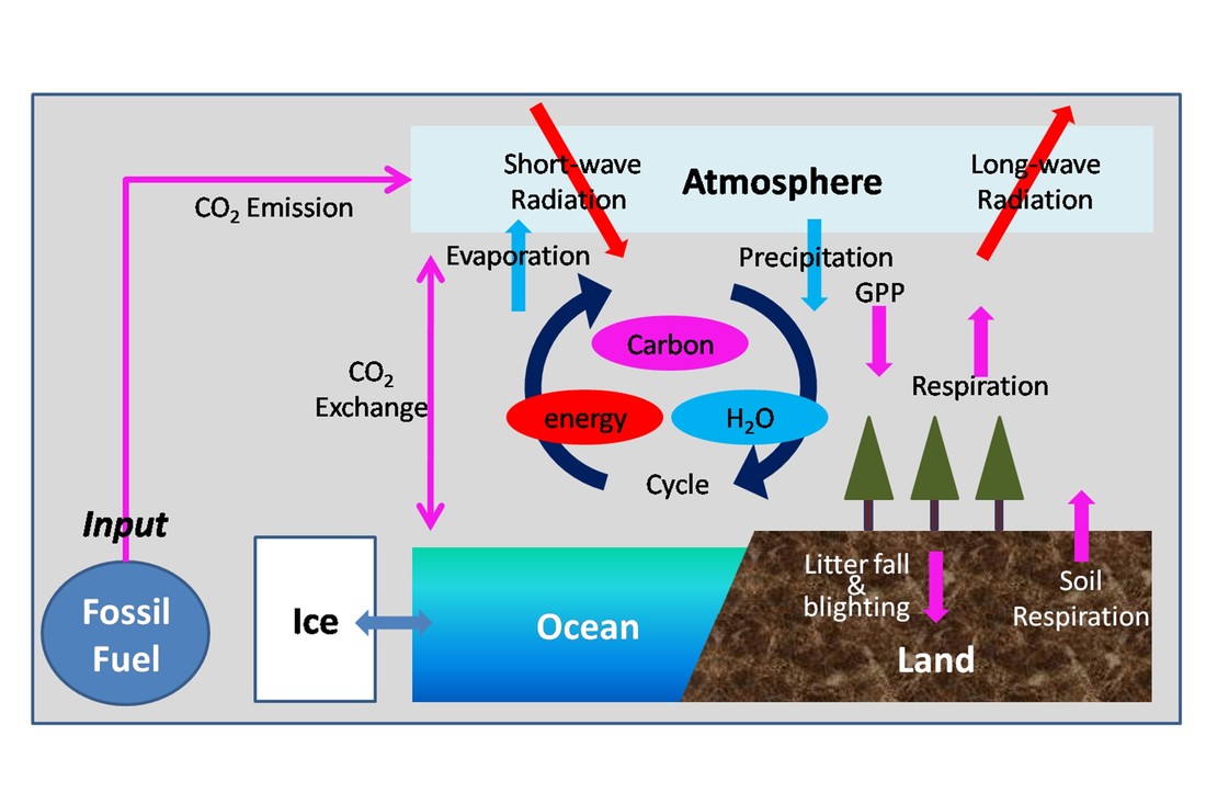
Mission of our group is "monitoring and modeling of earth system toward better prediction of our future earth." Our approach is to integrate and synthesize of available data and models to understand earth system in more comprehensive ways. Our main target is 'terrestrial biosphere' from regional to global scales. We use network of ground observation (e.g. FLUXNET, AsiaFlux), remote sensing data, numerical models (terrestrial ecosystem models), and atmospheric observations.
|
|
|
|
RESEARCH
Keywords:
Terrestrial Biosphere, Remote Sensing, Model, AsiaFlux,Model-data Integration, Synthesis, Carbon Cycle, Water Cycle, Machine Learning |
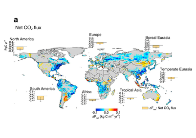
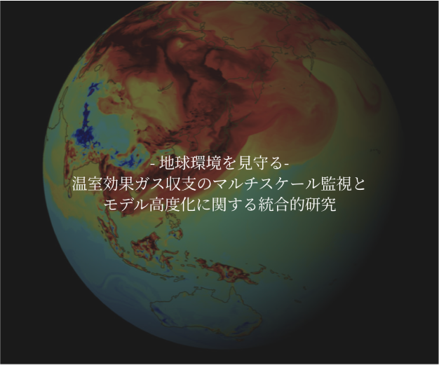
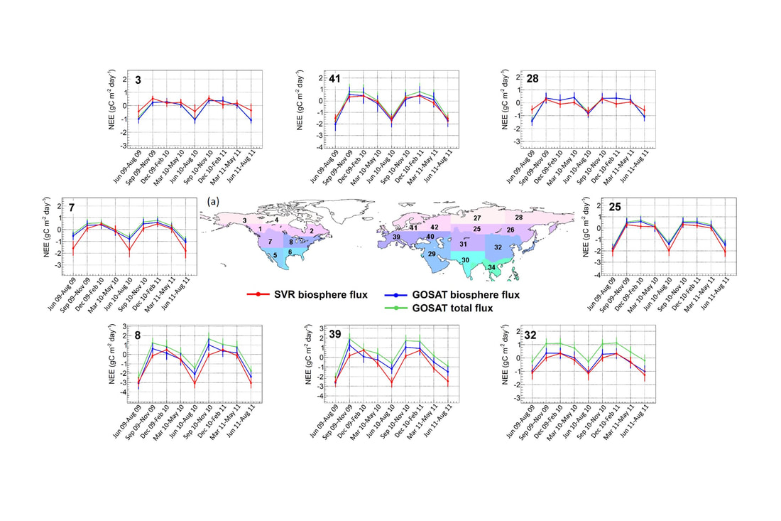
Understandings of Terrestrial CO2 Budget Changes at Global Scales by SynthesisUsing bottom-up approach (e.g ecosystem models) and top-down approaches (e.g. atmospheric inversions), we are working on quantification of terrestrial CO2 budget at various scales (e.g. global, southeast Asia, Asia). These works can become a contribution to global projects such as Future Earth. [Kondo et al. 2018 Nature Comm.; Kondo et al. 2018 GRL; Ichii et al. 2013]. 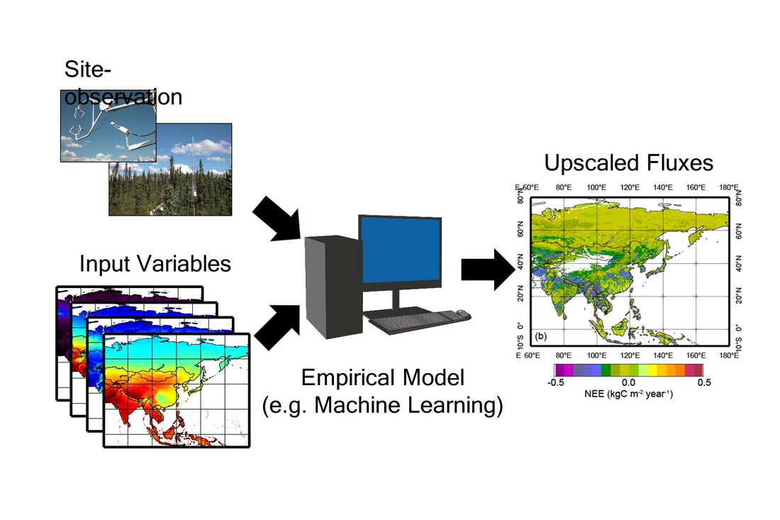
Data-driven estimation of terrestrial CO2 fluxes
|
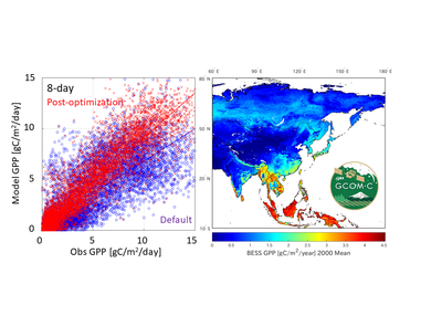
Development of a Terrestrial CO2 Flux Product for GCOM-C SGLI SensorUsing a diagnostic terrestrial biosphere model, AsiaFlux/FLUXNET observation network data, our group is developing a terrestrial CO2 flux (GPP, NPP, NEP) product for GCOM-C SGLI sensor (JAXA's satellite). Our product will be an official research products and released to public.
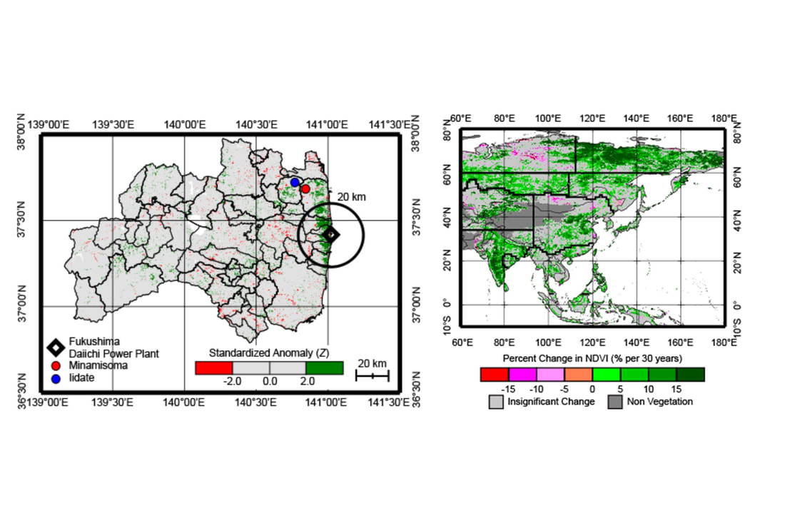
Satellite-based Monitoring of Vegetation Changes from Regional to Continental ScaleUsing long-term data of satellite remote sensing, we analyzed and detected vegetation and land cover changes from regional to global scales [e.g. Sekizawa et al. 2015; Ichii et al. 2013; Ichii et al. 2002; Kawabata et al. 2001]. |
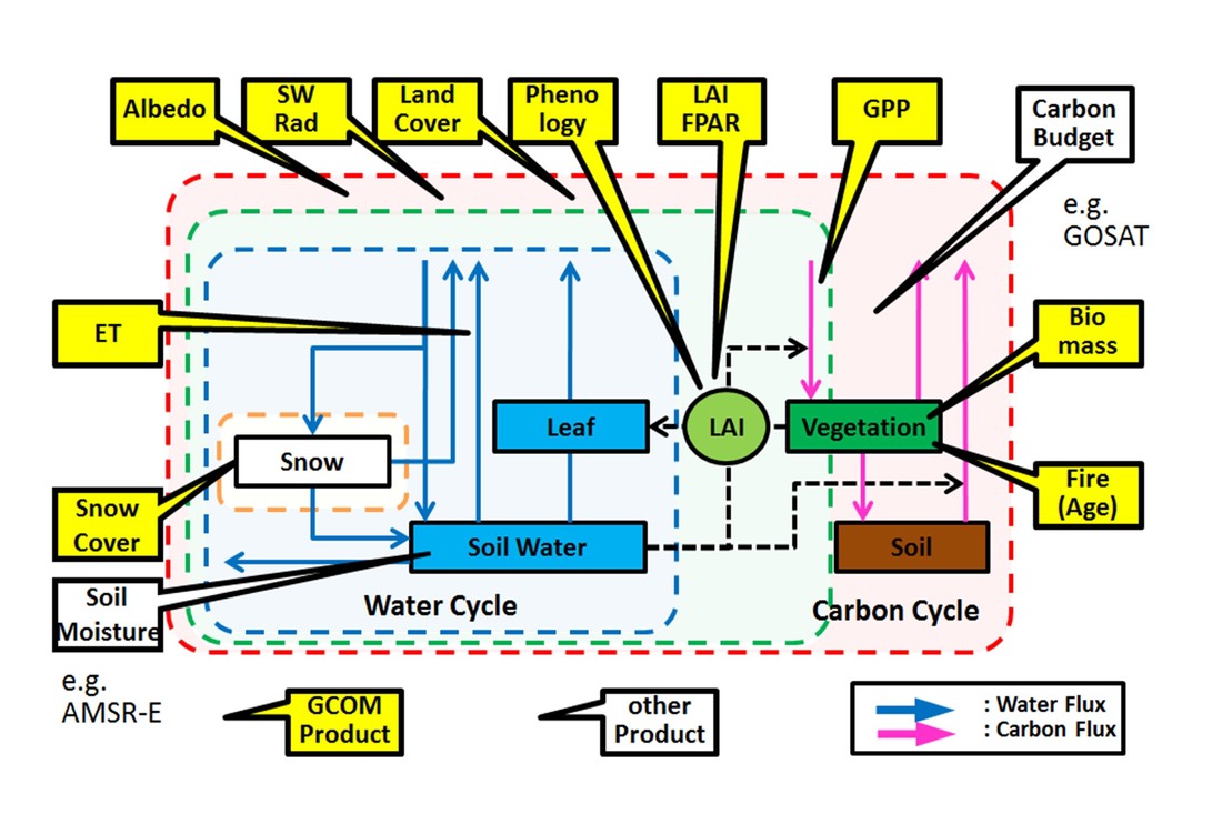
Data-Model Integration toward refinement of terrestrial ecosystem modelsBy integrating satellite data into terrestrial ecosystem model, we estimated unknown ecosystem parameters and successfully improved models. [Kondo et al. 2017; Ichii et al. 2007, 2009].
|
Top-down and Bottom-up Synthesis toward Better Understandings of Global Carbon Cycle
We are working on synthesis of multiple independent estimations of terrestrial CO2 fluxes. Estimations include top-down approach (atmospheric inversion model) and bottom-up approach (process-based model, data-driven model, satellite products). [Kondo et al. 2015; Ichii et al. 2017]. |
Earth System Modeling
We demonstrated that future projection of CO2 budget and climate might change if terrestrial carbon cycle model was improved using FLUXNET data. [Suzuki and Ichii, 2010]. We are also working on evaluating ESMs using available RS observation datasets. |
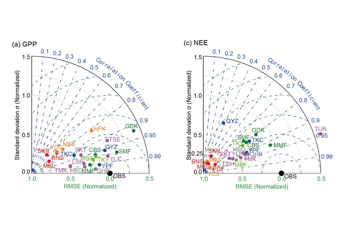
Model-data intercomparison in Asia etc.
We conducted model-data intercomparison project (Asia-MIP, CarboEastAsia-MIP, and Japan-MIP) to test current model performance using multiple models and observation data [Ichii et al. 2013; Ichii et al. 2010]. |
